TOWN & TOURISM
Along the George Elmy Lifeboat Way
....and Beyond
| [HOME] [SITE GUIDE] [TOWN] [GUESTBOOK] |
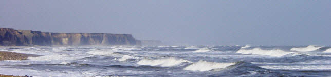
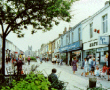
The whole coastline of Seaham in County Durham, England, has been dramatically opened-up to both motorists and walkers because of recent developments as the town has been regenerated. The recent opening of the George Elmy Lifeboat Way whose footpath forms part of the award-winning Durham Coastal Footpath means that visitors to the town can conveniently access and enjoy the beauty of the longest coastal promenade in the north east of England.
Seaham Harbour Online has created a gallery of photographs (by E.W.Mason) so that Harbour Lads and Lasses around the world can see the dramatic effect of the regenaration work on the town. We have tried to give a true impression of how it looks now and some of the old buildings, which will be removed as the Town Centre is re-developed in the coming year, have been included.
The gallery is made up of clickable thumbnail (small) photos which are linked to a larger version in each case. However, the pages containing the larger pictures have links which will allow you to view the pictures in turn.
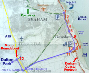
LOCATION MAP: We have created in the gallery a map which shows the locations of the pictures on the coastline. The map is contained within a "Pop-up" window and this has been set to a small enough size to allow you to examine it whilst still continuing to view the main picture. You can see any area of the map by using the scroll bars and you can either minimise the map window or remove it as you proceed.
The gallery consists
of photos taken at 12 different locations as indicated on the map.
Location 1 is near the Town Centre at the north end of the George Elmy Lifeboat Way.
At each location we have provide pictures taken in different directions. The walkway follows the road as far as Location 5 which is the roundabout at the entrance to Seaham Harbour Dock Company premises. However, it continues along the cliff tops to Noses Point and the Blast Beach. For visitors in cars there is the option to drive alongside the walkway from Location 5 using a rough (but easily negotiable) road to Noses Point.
From Noses Point, we have re-traced our path back to Location 5. We then take you out on the road to roundabouts 10 and 11 and towards the Murton Roundabout.Location 1 is near the Town Centre at the north end of the George Elmy Lifeboat Way.
At each location we have provide pictures taken in different directions. The walkway follows the road as far as Location 5 which is the roundabout at the entrance to Seaham Harbour Dock Company premises. However, it continues along the cliff tops to Noses Point and the Blast Beach. For visitors in cars there is the option to drive alongside the walkway from Location 5 using a rough (but easily negotiable) road to Noses Point.
We have deliberately used reasonable quality photos which means large file sizes and therefore more time to download them. If this proves to be unacceptable to a lot of people we will consider reducing the quality. Please let us know.
If you have any suggestions for other photos along this route please email us and we will consider the possibility of adding to the gallery.
